
$2,000,000
Chanhassen, MN 55318
MLS# 6799967

1 / 6


Property Description
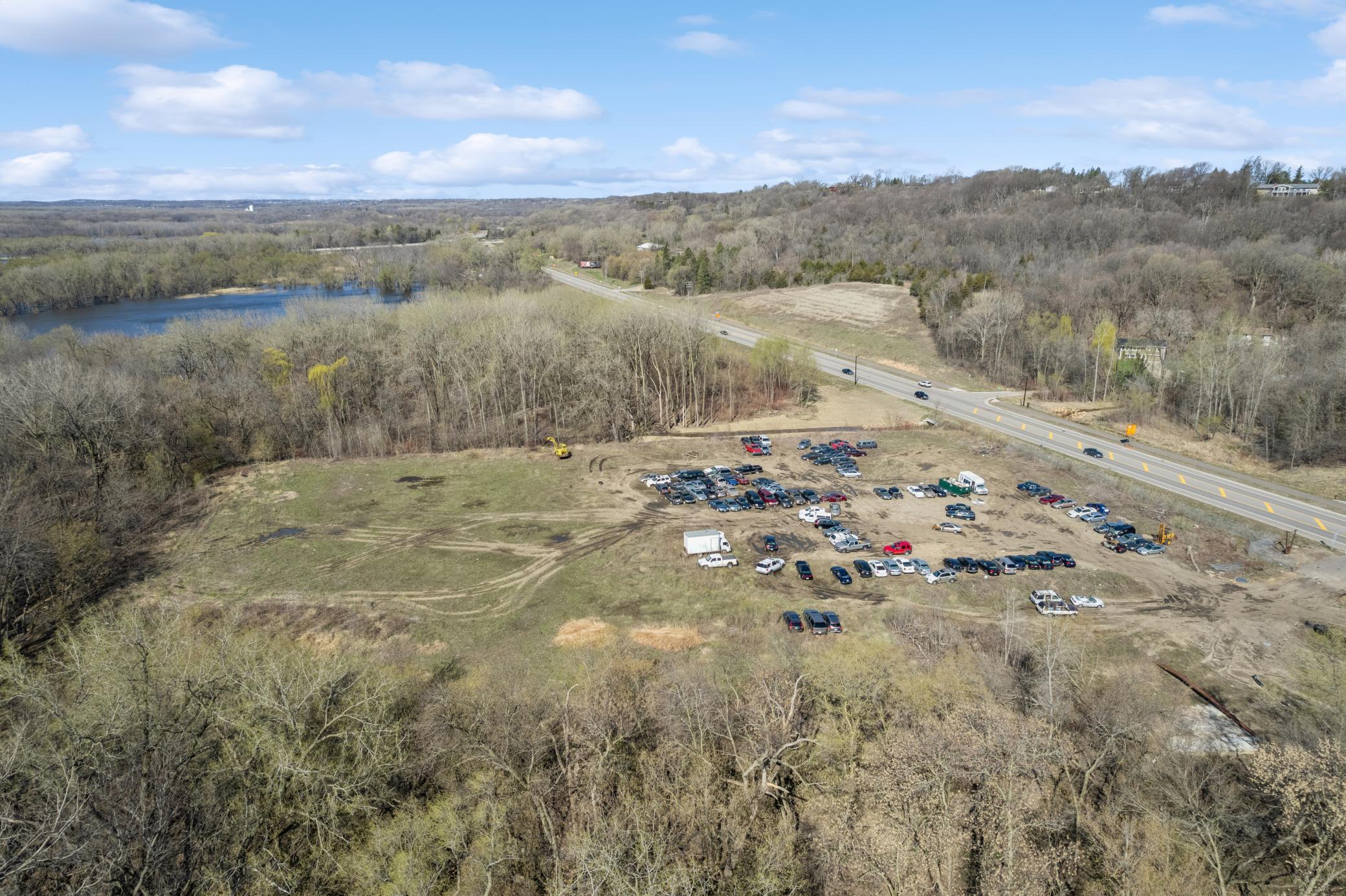
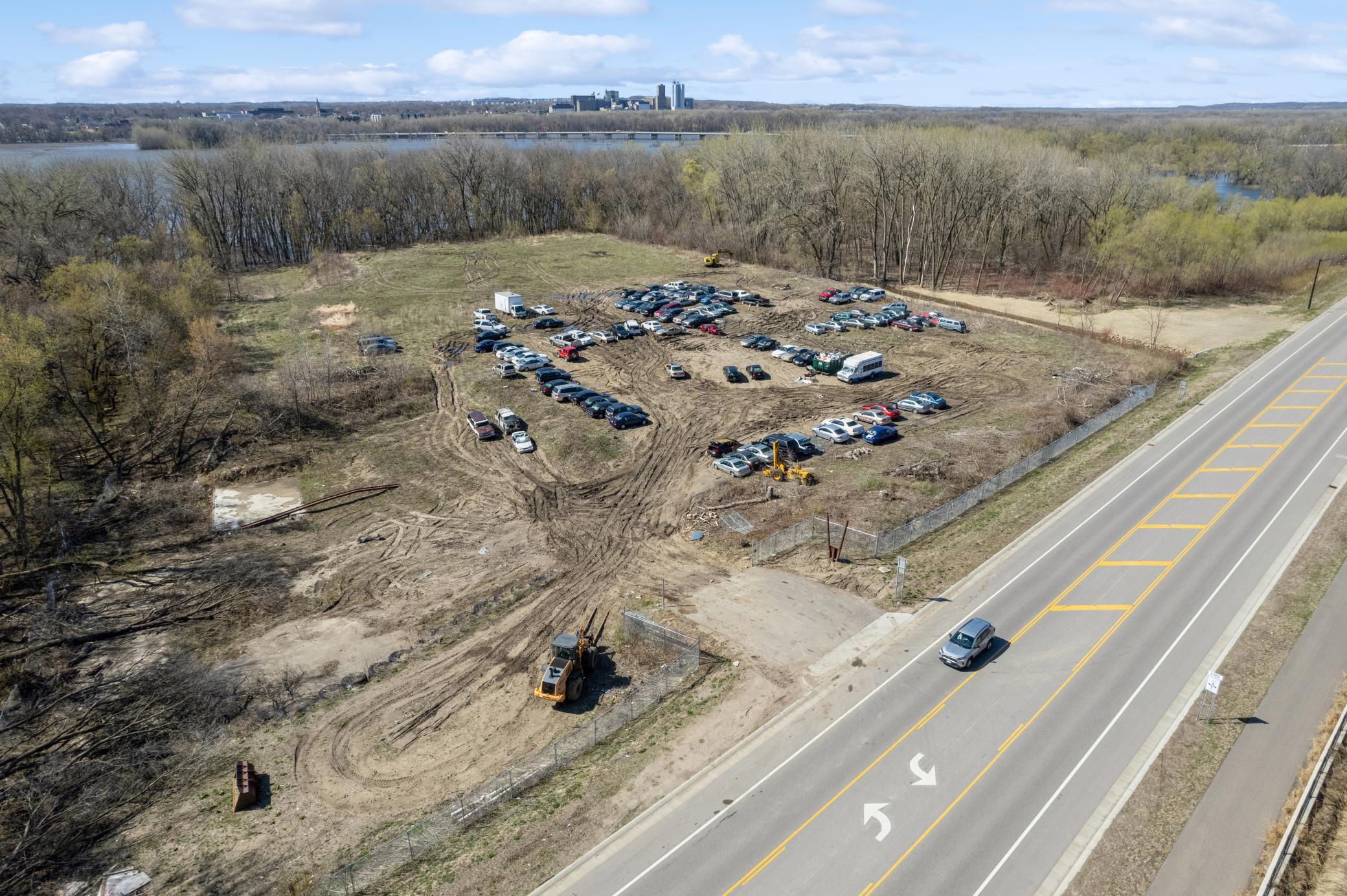
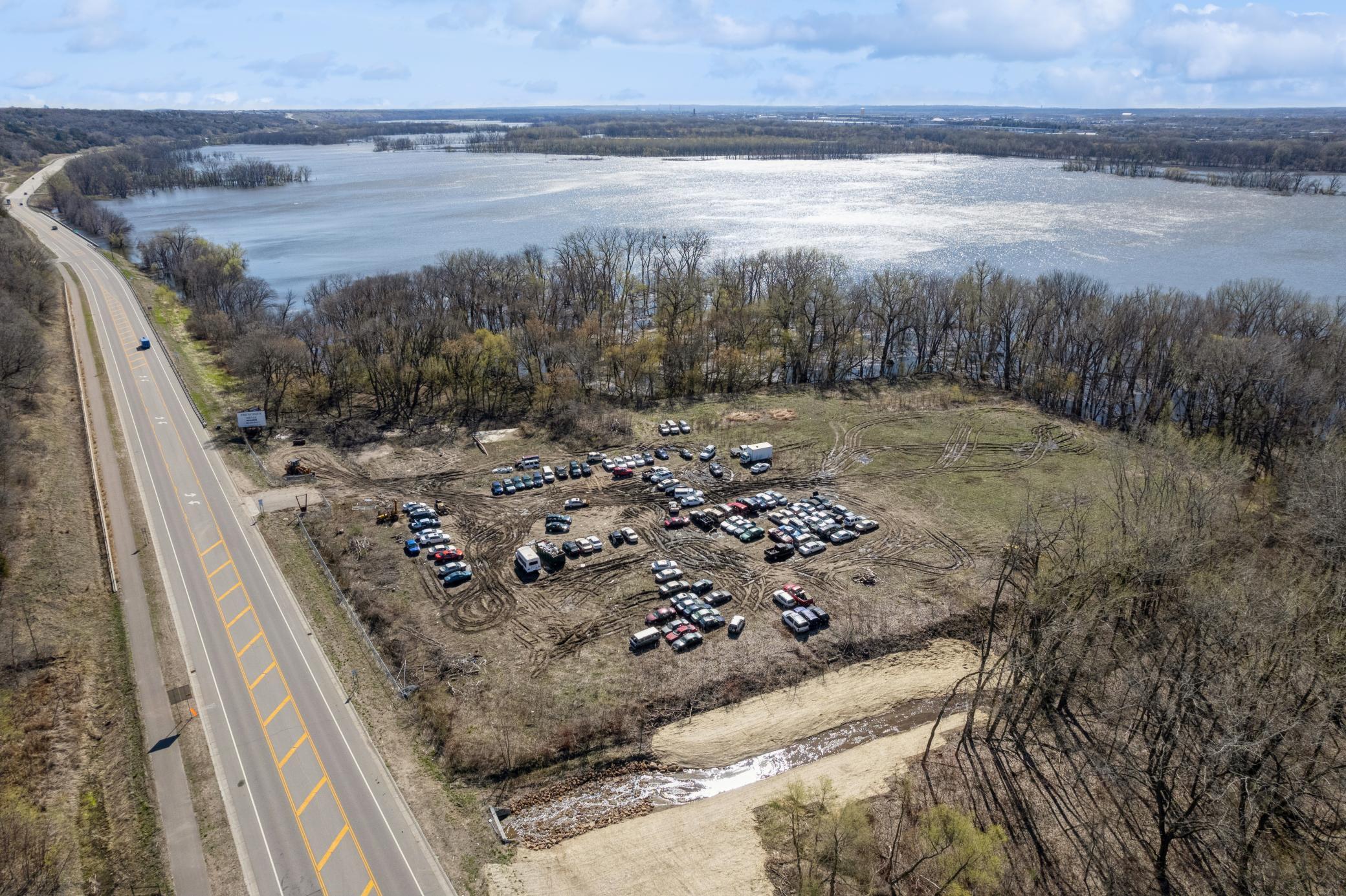
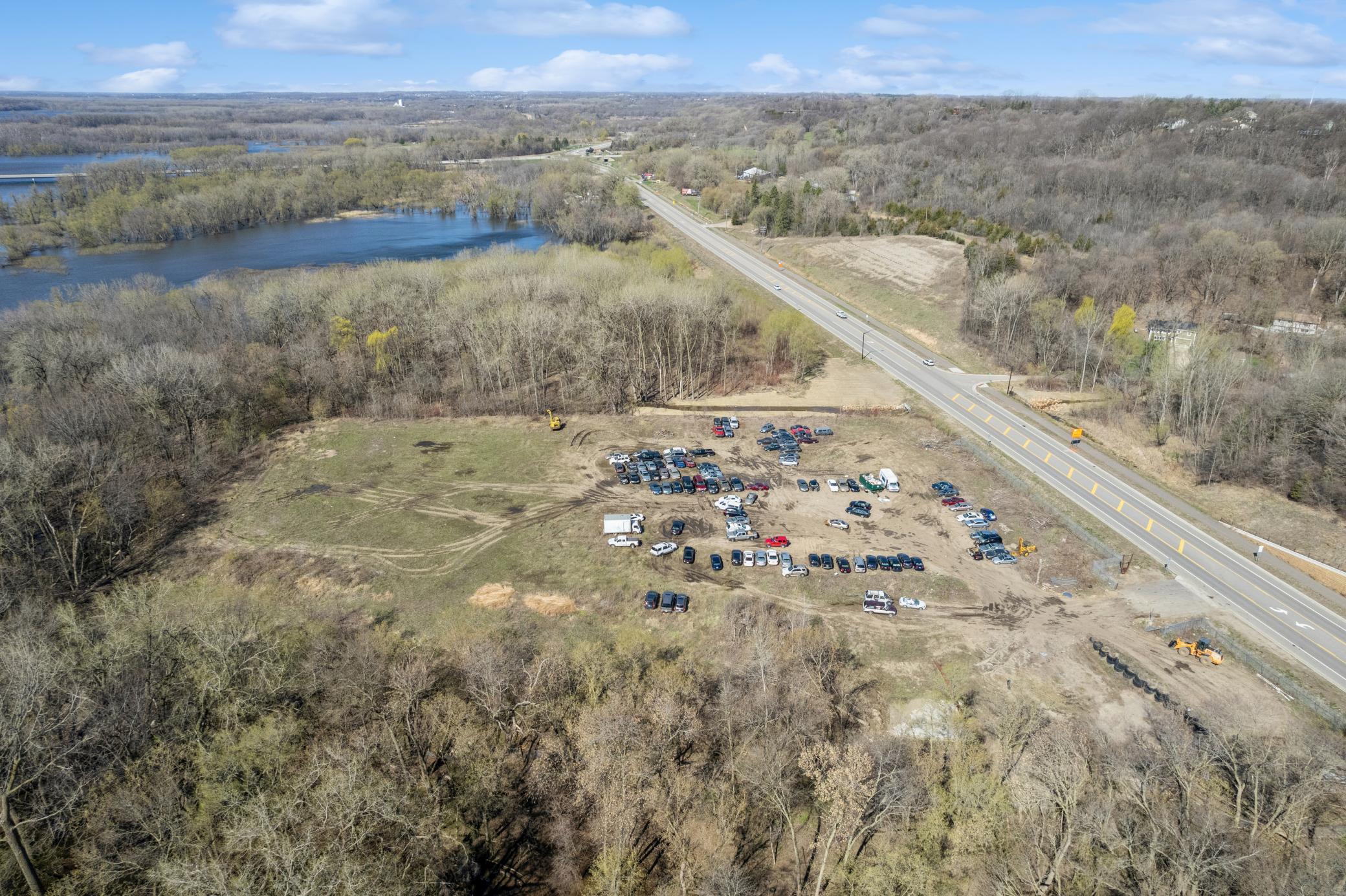
If you are looking to run an Auto Salvage Operation, maybe need a sit to store cars prior to selling or repairing them, or if you are a Tow company looking for a close-in overflow lot, this ~6 Acres site will work perfect for your operation. Yes, it has a Clean Environmental Report Yes, it has a Court Decision from 1974 stating this land can be used as Auto Salvage. Currently being operated as Tow Lot Overflow and Vehicle Collection Site. Owner will consider Contract for Deed Financing for Qualified Buyer.
Details
Maps
Documents
Contract Information
Owner is an Agent?: No
Auction?: No
Status: Active
Contingency: None
Current Price: $2,000,000
Original List Price: 2000000
ListPrice: 2000000
List Date: 2025-10-06
Office/Member Info
Association: SPAAR
General Property Information
Comp Sale YN: No
Development: No
Lot Measurement: Acres
Multiple PIDs?: No
Plat Recorded: No
Waterfront YN: No
Yearly/Seasonal: Yearly
Zoning: Industrial
Lot Dimensions: 415 675 404 622
Acres: 5.96
Association Fee: 0
Assessment Pending: Unknown
Location, Tax and Other Information
AssocFeeYN: No
Legal Description: SECTION 36 TOWNSHIP 116 RANGE 023 A TRACT OF LAND IN THE WEST HALF OF THE NORTHEAST QUARTER OF SECTION 36, TOWNSHIP 116, RANGE 23, CARVER COUNTY, MINNESOTA, DESCRIBED AS FOLLOWS: COMMENCING AT THE INTERSECTION OF THE EAST LINE OF SAID WEST HALF OF NORTHEAST QUARTER AND THE SOUTHERLY BOUNDARY OF STATE HIGHWAY NO. 212, AND RUNNING THENCE SOUTH ALONG SAID EAST LINE A DISTANCE OF 441.3 FEET; THENCE WEST AT RIGHT ANGLES TO SAID EAST LINE A DISTANCE OF 165.0 FEET; THENCE NORTH AND TO A POINT LYING ON SAID SOUTHERLY BOUNDARY AND A DISTANCE OF 165 FEET WESTERLY OF THE POINT OF BEGINNING A DISTANCE OF 415.0 FEET; THENCE EASTERLY ALONG SAID SOUTHERLY BOUNDARY TO THE POINT OF BEGINNING. CONTAINING 1.6 ACRES OF LAND, MORE OR LESS. A TRACT OF LAND IN
Listing City: Chanhassen
Map Page: 146
Municipality: Chanhassen
School District: Eastern Carver County Schools
School District Phone: 952-556-6100
Zip Plus 4: 246
Property ID Number: 250363000
Tax Year: 2023
Tax Amount: 1872
In Foreclosure?: No
Potential Short Sale?: Not disclosed
Lender Owned?: No
Directions & Remarks
Public Remarks: If you are looking to run an Auto Salvage Operation, maybe need a sit to store cars prior to selling or repairing them, or if you are a Tow company looking for a close-in overflow lot, this ~6 Acres site will work perfect for your operation.
Yes, it has a Clean Environmental Report
Yes, it has a Court Decision from 1974 stating this land can be used as Auto Salvage.
Currently being operated as Tow Lot Overflow and Vehicle Collection Site.
Owner will consider Contract for Deed Financing for Qualified Buyer.
Directions: On Flying Cloud Rd
Assessments
Assessment Balance: 0
Tax With Assessments: 1872
Builder Information
Builder Restrictions: Open
Development Status
Raw Land: 1
Insurance Fee
Insurance Fee: 0
Lease Details
Land Leased: Not Applicable
Miscellaneous Information
Homestead: No
Ownership
Fractional Ownership: No
Public Survey Info
Range#: 23
Section#: 36
Township#: 116
Restriction/Covenants
Other: 1
Topography
Flood Plain: 1
High Ground: 1
Low Land: 1
Available Utilities
Electricity Available: 1
Electricity Connected: 1
Water Not Available: 1
Improvements
Fence: 1
Public Road: 1
Land Inclusions
For Sale Sign: 1
Soil Test Available: 1
Location Tax and Other Information
House Number: 285
Street Name: Flying Cloud
Street Suffix: Drive
Postal City: Chanhassen
County: Carver
State: MN
Zip Code: 55318
Property Features
Available Utilities: Electricity Available; Electricity Connected; Water Not Available
Development Status: Raw Land
Improvements: Fence; Public Road
Land Inclusions: For Sale Sign; Soil Test Available
Topography: Flood Plain; High Ground; Low Land
 District Court Decision-1 - CUP - Mar 16
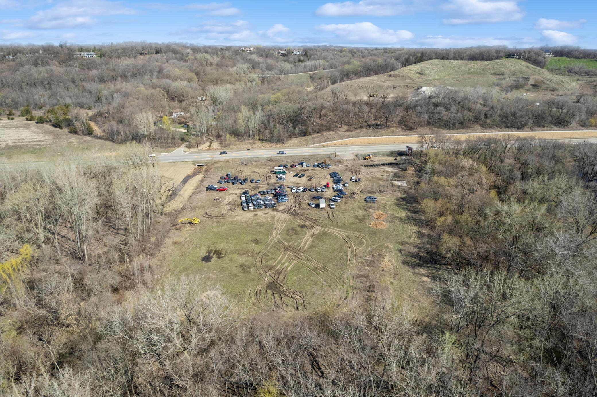

Listing Office: RE/MAX Advantage Plus
Last Updated: May - 27 - 2026
The data relating to real estate for sale on this web site comes in part from the Broker Reciprocity SM Program of the Regional Multiple Listing Service of Minnesota, Inc. The information provided is deemed reliable but not guaranteed. Properties subject to prior sale, change or withdrawal. ©2024 Regional Multiple Listing Service of Minnesota, Inc All rights reserved.